Street Image Compare: how to compare Google Street View and Mapillary in the same web page
If you ask to a crowd of people if they use Google Street View, probably you’ll have a positive answer.
If you ask, to the same crowd of people if they use Mapillary, probably the positive answers will be much less.
Despite the fact Mapillary, with lower means and possibilities, is proposed as a “crowd” alternative to the BigG service, its diffusion is not yet widespread, although there are places on the Earth whose geo referred images are available on Mapillary platform and are not available on Google Street platform.
The question is: is it possible to know, for a specific place, if geo referred images are available in one of these platforms or in both and, in that case, compare them?
I became aware about this problem after seeing an email in an Italian forum on Geographic Free and Open Source software (Gfoss.it); I’ve searched on the web but not successful.
So, starting from the OSM Map Compare idea, I’ve decide to build something by myself and in this way Street Image Compare was created.
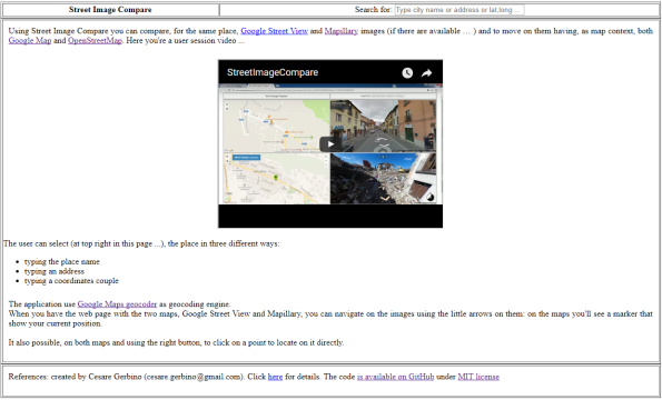
The application is very simple to use: for the same place you can compare Google Street View and Mapillary images (if they are both available) and “surf” on the streets having Google Maps and OpenStreetMap as reference.
The user can select the place in three different ways:
- typing the place name
- typing an address
- typing the coordinates couple
The application use Google Maps geocoder as geocoding engine.
When you open the app on the web page with the two maps, Google Street View and Mapillary, you can navigate on the images using the little arrows that are shown on the images: on the maps you’ll see a marker that show your current position.
On the both maps, and using the right buttons, is also possible to click on a specific point where you want to positionate yourself.
It’s quite easy to show the availability of Google Street View images (you can move the pegman on the map and immediately are shown some blue lines that show where the Google Street View images are present or not …) ….

…. for Mapillary is available a button “ON/OFF Mapillary sequences” on OpenStreetMap that draws some blue lines which show where the Mapillary images are present or not.
So, now with Street Image Compare you can compare Google Street View and Mapillary for every place in the world !!!
Here you’re a user session little video
On a technical point of view these are the data / services used:
- Google Maps API (rif. https://developers.google.com/maps/documentation/javascript/3.exp/reference)
- Google Street View (rif. https://developers.google.com/maps/documentation/javascript/3.exp/reference)
- Google Geocoder (rif. https://developers.google.com/maps/documentation/geocoding/intro)
- Open Street Maps via MapBox GL JS API (rif. https://www.mapbox.com/mapbox-gl-js/api/)
- Mapillary JS (rif. http://blog.mapillary.com/update/2016/02/10/mapillary-js.htmlhttp://blog.mapillary.com/update/2016/02/10/mapillary-js.html)
Beyond the mere comparison between two similar services (or, in any case with strong analogies …), that could be a coding exercise the application has some pratical use.
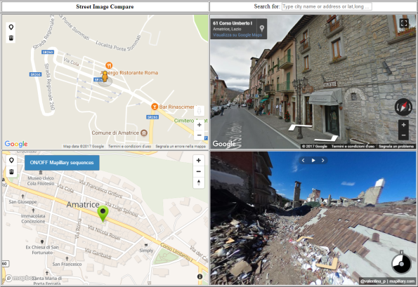
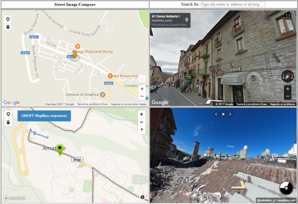
The pictures above are about Amatrice in Italy where last year, on August 24, 2016, there was a great earthquake: in this case you can compare places before and after the earthquake because after this event someone has captured and published the images on Mapillary platform.
You can move along Amatrice streets and the effect in really shocking !!
Starting from this example you can understand as, in case of natural events with big impacts, Mapillary, for its “crowd” nature, can be useful to capture images after the events and with Street Image Compare, you can immediately compare places before and after event. Very useful!
The application code is open source, available on GitHub, with MIT license.
Here you have some examples:
- Amatrice: http://www.cesaregerbino.com/Mapillary/StreetImageCompare/StreetImageCompare.html?lat=42.62856410000001&lng=13.291160300000001
- Area with Google Street View images available but NOT available on Mapillary: http://www.cesaregerbino.com/Mapillary/StreetImageCompare/StreetImageCompare.html?lat=44.95677499999999&lng=7.66733320000003
- Area with Mapillary images available but NOT available on Google Street View: http://www.cesaregerbino.com/Mapillary/StreetImageCompare/StreetImageCompare.html?lat=46.51460229999999&lng=11.66979409999999
- Pompei archaeological area: http://www.cesaregerbino.com/Mapillary/StreetImageCompare/StreetImageCompare.html?lat=40.7461572&lng=14.498934400000053
Note: thanks to Mariana Cristina Da Silva for the help on this post! 🙂

Davvero molto interessante e utile. Ti volevo chiedere un dettaglio..come hai fatto a caricare tutte le foto di mapillary e non solo quelle inserite da te? ho guardato il tuo codice e mi trovo una sola chiave alla stringa //add mapillary.
grazie
Roberto
Ciao Roberto,
grazie degli apprezzamenti. Per i dettagli che mi hai chiesto ….. in realtà non ho “caricato” solo le mie immagini … uso “tutte” le immagini di Mapillary 🙂 …. Mapillary offre una libreria Javascript che permette di includere le immagini (in modo interattivo … ), in soluzioni di web mapping. Si chiama Mapillary JS e il suo riferimento è qui: http://blog.mapillary.com/update/2016/02/10/mapillary-js.html. Come vedrai ci sono un pò di esempi di utilizzo. La logica che utilizzo (semplificando di molto ….), è che, dato un punto sulle mappa (Google o OSM … ), posiziono in “viewer” Mapillary in corrispondenza delle coordinate del punto e quindi così vedi le immagini di Mapillary in quel punto (se ve ne sono … ). Il codice è comunque open source (con licenza MIT), e si trova qui https://github.com/cesaregerbino/StreetImageCompare
Ciao Cesare, ho guardato il tuo codice ma essendo complesso e io in fase di studio..mi perdo qualcosa e non riesco a trovare su http://blog.mapillary.com/update/2016/02/10/mapillary-js.html il corrispondente codice per visuallizzare tutte le foto ma solo il seguente script
var mly = new Mapillary.Viewer(
‘mly’,
”,
”
);
con il quale inserisco le mie foto e sequenza di foto
grazie
Ciao Roberto,
in effetti se sei all’inizio partire dal mio codice di Street Image Compare non è la cosa migliore non perchè sia complesso ma è piuttosto articolato.
Prova a dare un’occhiata a questi due link:
https://github.com/mapillary/mapillary-js#examples
https://bl.ocks.org/oscarlorentzon/63644e3b2392f2f2b7d000af9c506da6
In particolare il secondo è l’esempio “più semplice”, diciamo l’Hello World per Mapillary …. ti basta avere un ID di Mapillary ed impostare l’id dell’immagine di Mapillary da cui vorresti partire …
Così dovresti essere in grado di muovere i primi passi …